Provocations for your projects

Today, I want you to think about how the readings about place this week might inform or influence your upcoming assignments for this class: the grant proposal, the Boise Wiki article (undergraduates only), and the augmented reality project.

Some questions to consider:

1. Following Lewis’s example of the monument and bungalows, do you anticipate highlighting any tensions in the places you are interpreting?  If so, how will you use those tensions in making your arguments about a place?

2. Which of Henderson’s “four dominant discourses on landscape”—landscape as landschaft, landscape as social space, the epistemological landscape, and the apocryphal landscape—will inform your projects?

3. Will the historical interpretation in your projects lean more in the positive or normative direction?

4. Hillier’s chapter on redlining in Philadelphia describes patterns of lending to home buyers and concludes that mid-twentieth-century redlining “is a more complicated process than many historians have appreciated” rather than a story of racial discrimination (88).  Still, her essay has relevance to home-buying and mortgage-lending issues today.  Will social justice, or at least informing ongoing policy discussions, be a guiding principle or goal of your project?

5. Beveridge’s essay on immigration, ethnicity, and race in New York highlights how GIS showed that although metropolitan New York is growing more culturally and racially diverse, it is also more segregated than ever.  If you’re proposing to use GIS in your grant proposal, what concepts or phenomena do you hope it will similarly clarify?

6. Cunfer’s piece on the Dust Bowl contests the common conception that human activities were the primary cause of dust storms in the 1930s.  Do you expect your project to disabuse historians and others of common misconceptions? If so, how will you make your case sufficiently strong to change people’s minds about what they think they know?

7. Fiege argues that historians and others studying the western U.S. must consider the intersection of private property and nature, both in terms of their physical presence (e.g., fences, cultivated fields, water, wildlife) and cultural beliefs (e.g. sanctity of private property, ideas about wildlife management).  How might a consideration of the ecological commons influence your project’s interpretation of a place or phenomenon?

8. Cunfer’s and Pearson and Collier’s chapters in Past Time, Past Place and Fiege’s chapter in Everyday America draw on both environmental and cultural data and history.  Would such a synthesis benefit your project?  Why or why not?  What kinds of data and evidence are you going to use, and how are you planning to synthesize them into a coherent project?

9. Sewell shows how, despite attempts to create separately gendered spaces (offices and department stores, for example), the reality of gendered interaction in downtown San Francisco, especially at street level, was more complicated.  How is your ongoing work on your project balancing the analysis of geographical or architectural space with research into the actual historical interaction among people in that space?

10. Rojas takes an environment that is familiar to him—the streets and yards of East Los Angeles—and makes them comprehensible to readers who might find the spaces and interactions foreign or even (at first glance) undesirable.  How does your project make comprehensible and interesting a concept, phenomenon, or place people might find unfamiliar, uninteresting, or even strange?
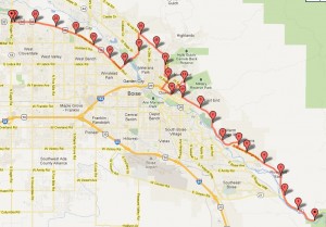
Through Boise…

Molly & Ellie

Begin at Lucky Peak
Travel down Warm Springs Ave. (Warm Springs Historic DistrictOld Idaho Penitentiary & Pioneer Cemetery)
Ave B North
Fort Street to Robbins Rd.
Robbins Rd. to Collins Rd.
N. VA Hospital Loop past the VA Medical Center
5th St. to Hays to 6th St.
6th St. past the Capitol & Old Ada County Courthouse
6th St. past the Basque Block
Front Street to 13th (Linen District – dying area)
13th St. to Hays
Hays to Harrison Blvd.
Harrison Blvd. to Hill Rd.
Hill Rd. to 36th
36th to Veterans Memorial Parkway (Old Soldiers Home at Veterans Memorial Park)
Veterans Memorial Parkway to Chinden
Chinden Blvd to Eagle Road. (booming area)

Scenic Sunday (Cross) Section

Ryan Regis

April Raine

Eric Schooley

Just like the pioneers, come from the East. (I-84) This will lead you nicely onto the Gowen exit which takes you to Federal Way (on this piece you will be given a panoramic view of the valley you are about to explore, as well as the famous Table Rock) and then Turn on Apple. Apple leads to Park Center (an long-settled and affluent part of town, with lots of historical markers of interest), and then onto Beacon to Broadway (look to your left and you will get to see a part of campus and the BSU stadium) and then left on Idaho which will lead downtown past the Capitol (take note of the neo-classical architecture of the Capitol Building, complete with a Golden statue of Nike atop the dome). After a few more miles, head North on 13th (if you’re quick, and equipped with our interactive app, you may see the area which used to be Boise’s only ethnic enclave, China Town!) towards Hyde Park (an interesting area due to the confluence of new money in older areas, traditionally populated by lower income residents). After a lovely view of the neighborhood and big trees, head west on Hill Road for a quick jaunt through what could be described as semi-urban ranches which used to be much more prevalent in this area. Soon, you will find Hwy 55, take a left to the south, and then right on State, which will lead to a left turn to the South on Eagle Road. Eagle will lead to Chinden Boulevard where you will take a right (west) (here we find an industrial center of the valley, a center which used to be much more active). Soon you will find the City of Caldwell, our trip is over! Good luck getting home without our help!


An Ode to Mobile Boise

Ana, Aaron, Kyle, Jim

This cross section revisits the history, and importance, of transportation to the development of Boise. Starting with the early years trollies and wagon trails, moving into urban sprawl, air traffic and freeways, ending with the transformation into a bicycle friendly city. This cross section might encourage people to ask the question “How does a city provide transportation to its citizens? How has it changed, and what are the challenges facing city planners for the future of transportation in Boise?”

Start: Trolley House: To view the early history of traveling by electric street cars.
Military Reserve: see the old wagon trail to Idaho City.
Greenbelt: The importance of public pedestrian traffic.
Boise Municipal Airport (Boise State University): Imagine BSU as an airport.
Train Depot: Imagine travelers arriving in Boise.
Down Americana: To see how city planners wanted people to drive into downtown.
Connector (1-84): Travel through Boise’s suburban neighborhoods on a freeway.
Fairview view exit: Strip malls and the importance of cars to current modes of travel.
Car lots: The reliance on cars for traveling in Boise.
Cole, Mall: The suburban shopping center, limited public transportation and limited bicycles and pedestrians.
Veterans Memorial: Bicycles and cars sharing space.
Hill Road Bicycle memorial: The conflict between cars and bicycles.
Hyde Park and the North End: Watch hipsters on fixies.
8th and Idaho: City planners reduce car lanes and encourage pedestrians and bicycles

Considering the landscape (October 15)

Questions for discussion

1. In what ways do buildings and landscapes have a history?  How is that history useful to us as people living in the landscape?  As historians, what tactics can we use to make that history more visible?

2. Do you agree with Lewis’s assertion that “the American educational system, both formal and informal, actively discourages the act of looking and thinking about what one sees” (93-94)?  Give some examples from your own experiences as a learner and/or teacher.

3. Do you agree with Lewis’s argument that the war monument and the California bungalows in Bellefonte represent social and cultural tensions?  Explain your answer.

4. Explain in your own words Henderson’s “four dominant discourses on landscape”: landscape as landschaft, landscape as social space, the epistemological landscape, and the apocryphal landscape. Towards which discourse(s) do you lean philosophically and in your own research and writing?

5. What is the difference between a positive modality and a normative one? How might a normative discourse lead to a different kind of landscape analysis or history than a positive one?

6. Henderson writes, “If landscape was to be about not only surfaces, but also alertness to social structure, and to fairness and justice, [J. B.]  Jackson reminded us it would also have to be about questioning how far the study of landscape can take us and how landscape could be redefined in terms of concern with social and economic justice” (197) Do you think historical interpretations of a landscape ought to be deployed in the service of social justice?  Why or why not?  If so, for whom and by whom?

7. Is landscape study a good way to learn history?  Why or why not?

Activity

Suggest a cross-sectional drive through Boise that makes an argument about Boise’s historical development, following the rules laid out by Grady Clay on pages 120-122.  As you do, keep in mind Timothy Davis’s essay on the American highway landscape and the importance of the car, as well as “other-directed architecture,” in the physical and economic development of a city.  In a blog post, map or describe your cross-section, then explain what argument your cross-section makes, and why you chose the route you did.  (Hint: for mapping, if you have a laptop or tablet, you can use Gmap Pedometer, take a screenshot, and upload it to your post.)


View Larger Map

Resources for October 10: Discussion questions, GIS, NEH grants

Questions for discussion

1. In the examples in Past Time, Past Place, how did using GIS change researchers’ interpretation of historical data or cultural resources ?

2. In what specific ways can GIS aid in interpretation of historic sites for the public?  What might be some liabilities of asking the public to use GIS or GPS as they try to understand a historic site?

3. GIS is often praised by historians as a way to make visible historical trends that otherwise might have been missed.  Are there ways that GIS might obfuscate instead of enlighten?

4. Imagine you were assigned to interpret the “urban renewal” of downtown Boise in the 1970s for a public audience.  Which approach is more interesting to your group: using GIS to recreate that pre-demolition landscape as a 3D visualization, or using GIS data layers to try to explain the causes and effects of this particular urban redevelopment?  Explain your answer.

GIS resources and inspiration for your group projects

National Historical Geographic Information System: “The National Historical Geographic Information System (NHGIS) provides, free of charge, aggregate census data and GIS-compatible boundary files for the United States between 1790 and 2010.”

What Historians Want from GIS

The New York City Historical GIS Project

Geographies of the Holocaust

Digital Humanities GIS Projects

NEH Digital Humanities grant project directors lightning talks

Round 1:

Round 2: